1915 Map of Hominy
USGS Topo · Published 1949About this map
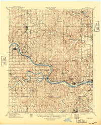
The confluence of the Cimarron River and Arkansas River forms the geographical heart of this northeast Oklahoma region, surveyed just years after statehood. This landscape is defined by the early 20th-century expansion of railroads and petroleum interests, seen in the density of lines such as the St Louis and San Francisco and Midland Valley. The map documents the spatial relationship between growing industrial hubs like Sand Springs and Sapulpa and established tribal locales such as Black Dog Indian Village. For the family historian, the sheet is an exceptional record of rural infrastructure, pinpointing numerous district landmarks like Mound Valley School, Cottonwood School, and Limestone School before decades of reservoir construction and urbanization altered the local topography. In the northwest, the settlement of Hominy serves as a focal point for the surrounding Osage Nation lands, while West Tulsa and Red Fork mark the burgeoning edge of the regional oil economy.
Find a feature on this map
84 named features on this map. Tap any name to fly to it.
Don’t see what you’re looking for? This feature index may not catch every label — zoom into the map to look around manually.
Map Details
Editions of this 1915 Hominy Map
2 editions found

Other maps of this area

1896 · Okmulgee
USGS Topo · 1:125,000

1900 · Okmulgee
USGS Topo · 1:125,000

1901 · Claremore
USGS Topo · 1:125,000

1901 · Nowata
USGS Topo · 1:125,000

1901 · Nuyaka
USGS Topo · 1:125,000

1909 · Pawhuska
USGS Topo · 1:125,000

1910 · Pawhuska
USGS Topo · 1:125,000

1912 · Hominy
USGS Topo · 1:125,000

1914 · Kiefer
USGS Topo · 1:62,500

1914 · Nowata
USGS Topo · 1:125,000