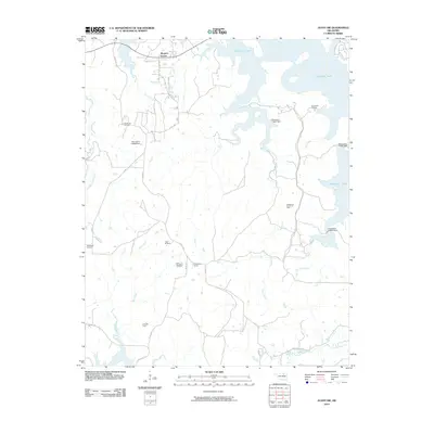
2010 Map of Avant SW
USGS Topo · Published 2010About this map
Skiatook Lake dominates the northeastern landscape, its complex shoreline and numerous dams such as Oknoname 113067 Dam shaping the modern geography of this region. The area remains heavily defined by its petroleum legacy, with several active production zones including the Wildhorse Oil Field, Madalene Oil Field, and Prue Oil Field dotting the hills. The intersection at Morgans Corner and large private holdings like Triple M Ranch and Arrowhead Ranch illustrate the transition from open grazing land to more managed rural infrastructure. Numerous waterways, including Hominy Creek, Wildhorse Creek, and Tall Chief Creek, carve through the terrain, feeding into the reservoir system and defining the natural drainage patterns of the Osage and Tulsa County borderlands.
Find a feature on this map
32 named features on this map. Tap any name to fly to it.
Don’t see what you’re looking for? This feature index may not catch every label — zoom into the map to look around manually.
Map Details
Editions of this 2010 Avant SW Map
This is the sole edition of this map. No revisions or reprints were ever made.
Other maps of this area

1912 · Hominy
USGS Topo · 1:125,000

1915 · Hominy
USGS Topo · 1:125,000

1915 · Hominy
USGS Topo · 1:62,500

1955 · Enid
USGS Topo · 1:250,000

1956 · Sand Springs
USGS Topo · 1:24,000

1958 · Enid
USGS Topo · 1:250,000

1958 · Keystone Dam
USGS Topo · 1:24,000

1958 · Wekiwa
USGS Topo · 1:24,000
1963 · Avant SE
USGS Topo · 1:24,000
1966 · Avant NW
USGS Topo · 1:24,000