
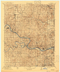
1915 Map of Hominy
USGS Topo · Published 1928About this map
Black Dog (Indian Village) and the busy oil-era settlement of Oil City anchor this portrait of northeast Oklahoma as it transitioned through the early twentieth century. The landscape is defined by the sweeping curves of the Arkansas River and Cimarron River, which meet near the riverfront community of Keystone. This era is marked by a dense network of rural infrastructure, from the St Louis and San Francisco RR lines to a high concentration of country schools such as Brannon School and Sunny Slope School. To the south, Sapulpa emerges as a growing hub, supported by the Sapulpa Reservoir and the Midland Valley RR. The map records a moment when local post offices like Taneha and small junctions like Wekiwa served as critical points of connection for farming and mineral extraction families across Osage and Creek counties.
Find a feature on this map
82 named features on this map. Tap any name to fly to it.
Don’t see what you’re looking for? This feature index may not catch every label — zoom into the map to look around manually.
Map Details
Editions of this 1915 Hominy Map
2 editions found
Other maps of this area

1909 · Pawhuska
USGS Topo · 1:125,000

1910 · Pawhuska
USGS Topo · 1:125,000

1912 · Hominy
USGS Topo · 1:125,000

1915 · Hominy
USGS Topo · 1:125,000

1929 · Yale
USGS Topo · 1:62,500

1929 · Skedee
USGS Topo · 1:62,500

1931 · Skedee
USGS Topo · 1:62,500

1932 · Yale
USGS Topo · 1:62,500

1932 · Fairfax
USGS Topo · 1:62,500

1955 · Enid
USGS Topo · 1:250,000