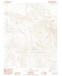
1985 Map of Avawatz Pass
USGS Topo · Published 1985About this map
The Avawatz Mountains define the character of this desert landscape, where the southern reaches of Death Valley meet the restricted lands of the Fort Irwin Military Reservation. Water is the primary driver of human activity here, evidenced by a series of named springs including Cottonwood Spring, Cave Spring, and Denning Spring (Dry). The topography suggests a history of resource exploration, as numerous unidentified Prospect and Prospects sites are scattered along the steep elevation contours, particularly near Arrastre Spring. This name implies the historical presence of an arrastre — a primitive mule-powered mill used to crush ore — pointing to the difficult mining operations that once characterized this remote corner of San Bernardino County. The isolation of the terrain is further emphasized by the prominent Avawatz Pass, a natural gateway through the high ridges.
Find a feature on this map
15 named features on this map. Tap any name to fly to it.
Don’t see what you’re looking for? This feature index may not catch every label — zoom into the map to look around manually.
Map Details
Editions of this 1985 Avawatz Pass Map
2 editions found
Other maps of this area

1933 · Avawatz Mountains
USGS Topo · 1:250,000

1947 · Trona
USGS Topo · 1:250,000

1948 · Red Pass Lake
USGS Topo · 1:62,500

1948 · Trona
USGS Topo · 1:250,000

1948 · Leach Lake
USGS Topo · 1:62,500

1948 · Avawatz Pass
USGS Topo · 1:62,500

1948 · Tiefort Mountains
USGS Topo · 1:62,500

1951 · Tiefort Mountains
USGS Topo · 1:62,500

1951 · Avawatz Pass
USGS Topo · 1:62,500

1951 · Red Pass Lake
USGS Topo · 1:62,500