1982 Map of Avent
USGS Topo · Published 1982About this map
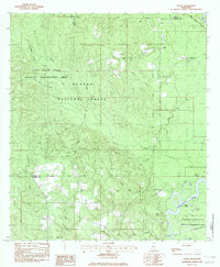
The Pascagoula River snakes through the southeastern corner of this landscape, creating a complex network of backwaters including Davis Dead River, Dace Lake, and the Dace Eddy. This 1982 provisional study documents the rural character of the borderlands between Greene and George Counties within the De Soto National Forest. Settlement is concentrated around the Illinois Central Gulf railroad line, which passes through the small community of Avent and the McClelland station. The interior is defined by the Whiskey Creek Hills and numerous watercourses like Whiskey Creek and Black Creek. Local genealogy is well-preserved through several established landmarks, including Mt Rose Ch, Leaf Ch, and family burial grounds such as Pipkin Cem and Fairley Cem.
Find a feature on this map
33 named features on this map. Tap any name to fly to it.
Don’t see what you’re looking for? This feature index may not catch every label — zoom into the map to look around manually.
Map Details
Editions of this 1982 Avent Map
This is the sole edition of this map. No revisions or reprints were ever made.
Other maps of this area

1941 · Lucedale
USGS Topo · 1:62,500

1943 · Lucedale
USGS Topo · 1:62,500

1947 · Beaumont
USGS Topo · 1:62,500

1947 · Benndale
USGS Topo · 1:62,500

1949 · Beaumont
USGS Topo · 1:62,500

1949 · Benndale
USGS Topo · 1:62,500

1953 · Hattiesburg
USGS Topo · 1:250,000

1953 · Mobile
USGS Topo · 1:250,000

1957 · Mobile
USGS Topo · 1:250,000

1958 · Hattiesburg
USGS Topo · 1:250,000