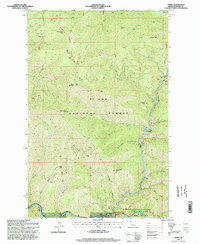
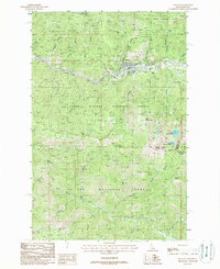
1995 Map of Avery
USGS Topo · Published 1998About this map
The St Joe Wild and Scenic River carves a deep path through this portion of the St Joe National Forest, serving as the primary geographical anchor for the settlement at Avery. This 1990s revision reveals the complex relationship between the steep mountain terrain and the infrastructure required to navigate it. High ridges such as the Slate Creek Divide and peaks like Marcus Cook Peak and Storm Mountain dominate the landscape, while the river valley at the bottom of the quadrangle is punctuated by a series of engineered features including Tunnel 18, Tunnel 19, and Tunnel 22. A Water Tank near the riverbank at Avery points to the area's historical logistical needs. From the fire-watch vantage point of the Arid Peak Lookout to the tucked-away Cedar Lake, the map traces a network of gulches and creeks like Jitney Gulch and Trego Gulch that feed into the main waterway.
Find a feature on this map
41 named features on this map. Tap any name to fly to it.
Don’t see what you’re looking for? This feature index may not catch every label — zoom into the map to look around manually.
Map Details
Editions of this 1995 Avery Map
This is the sole edition of this map. No revisions or reprints were ever made.
Other maps of this area

1914 · Avery
USGS Topo · 1:125,000

1917 · Avery
USGS Topo · 1:125,000

1956 · Saltese
USGS Topo · 1:62,500

1956 · Wallace
USGS Topo · 1:250,000

1957 · Wallace
USGS Topo · 1:62,500

1960 · Wallace
USGS Topo · 1:250,000
1969 · Hoyt Mountain
USGS Topo · 1:24,000
1969 · Three Sisters
USGS Topo · 1:24,000
1969 · Fishhook Creek
USGS Topo · 1:24,000
1988 · Mullan
USGS Topo · 1:24,000