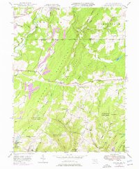
1947 Map of Avilton
USGS Topo · Published 1976About this map
The Mason and Dixon Line serves as a prominent boundary on this survey, dividing the high ridges of Somerset County, Pennsylvania, from the dense woodlands of Garrett County, Maryland. This mid-century study reveals a landscape defined by sharp elevation changes between Elk Lick Ridge and Big Savage Mtn. Scattered rural life is anchored by small settlements like Avilton and New Germany, while the National Pike winds past landmarks such as Mt Zion Ch and its associated Mt-Zion Ch Cem. Much of the Maryland side is dominated by the Savage River State Forest, where numerous drainages like Wolf Den Run and Bluelick Run feed into the Savage River. The presence of several schools, including Avilton Sch and Crossroad Sch, alongside family-named burial grounds like Blocher Cem, provides a detailed view of the community structure before modern development altered the region's character.
Find a feature on this map
53 named features on this map. Tap any name to fly to it.
Don’t see what you’re looking for? This feature index may not catch every label — zoom into the map to look around manually.
Map Details
Editions of this 1947 Avilton Map
4 editions found
Other maps of this area

1898 · Frostburg
USGS Topo · 1:62,500

1899 · Grantsville
USGS Topo · 1:62,500

1901 · Frostburg
USGS Topo · 1:62,500

1904 · Grantsville
USGS Topo · 1:62,500

1908 · Frostburg
USGS Topo · 1:62,500

1921 · Meyersdale
USGS Topo · 1:62,500

1923 · Berlin
USGS Topo · 1:48,000

1929 · Berlin
USGS Topo · 1:62,500

1939 · Meyersdale
USGS Topo · 1:62,500

1944 · Berlin
USGS Topo · 1:62,500