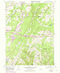
1947 Map of Avilton
USGS Topo · Published 1982About this map
The Mason and Dixon Line serves as a stark historical boundary on this landscape, separating the rugged Maryland-Pennsylvania borderlands during the mid-20th century. To the south, the Savage River State Forest covers vast tracts of the Meadow Mountain Ridge, where remote settlements like Avilton and New Germany are anchored by local institutions such as St Annes Ch and Mt Beulah Ch. The terrain is defined by its drainage patterns, with the Casselman River and Savage River carving through the highlands. Transportation in this era is dominated by the National Pike, which passes through Piney Grove and High Point. Genealogists may find particular value in the documentation of family-named landmarks and rural burial sites, including the Merrbach Cem and Blocher Cem, alongside now-vanished educational centers like Crossroad Sch.
Find a feature on this map
59 named features on this map. Tap any name to fly to it.
Don’t see what you’re looking for? This feature index may not catch every label — zoom into the map to look around manually.
Map Details
Editions of this 1947 Avilton Map
4 editions found
Other maps of this area

1898 · Frostburg
USGS Topo · 1:62,500

1899 · Grantsville
USGS Topo · 1:62,500

1901 · Frostburg
USGS Topo · 1:62,500

1904 · Grantsville
USGS Topo · 1:62,500

1908 · Frostburg
USGS Topo · 1:62,500

1921 · Meyersdale
USGS Topo · 1:62,500

1923 · Berlin
USGS Topo · 1:48,000

1929 · Berlin
USGS Topo · 1:62,500

1939 · Meyersdale
USGS Topo · 1:62,500

1944 · Berlin
USGS Topo · 1:62,500