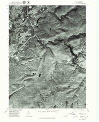
1976 Map of Avoca
USGS Topo · Published 1979About this map
The Lackawanna River corridor defines the industrial and residential heart of this region, where the dense grid of Old Forge and Avoca transitions into the steep, wooded hills of Luzerne and Lackawanna counties. This 1976 orthophotograph captures the complex transport infrastructure of the mid-1970s, including the airfield and the winding path of Spring Brook as it cuts through the upland terrain. The map provides an overhead view of the post-coal landscape, where small settlements like Suscon and Dupont are situated amidst a network of highways and rail lines that facilitated the movement of goods and people through the Wyoming Valley. The photographic detail offers a clear look at the spatial relationship between the river towns and the higher elevations to the east, revealing the footprint of mid-century development and the natural drainages that shaped local growth.
Find a feature on this map
6 named features on this map. Tap any name to fly to it.
Don’t see what you’re looking for? This feature index may not catch every label — zoom into the map to look around manually.
Map Details
Editions of this 1976 Avoca Map
This is the sole edition of this map. No revisions or reprints were ever made.
Other maps of this area

1889 · Scranton
USGS Topo · 1:62,500

1891 · Wilkesbarre
USGS Topo · 1:62,500

1891 · Scranton
USGS Topo · 1:62,500

1893 · Pittston
USGS Topo · 1:62,500

1893 · Scranton
USGS Topo · 1:62,500

1894 · Wilkesbarre
USGS Topo · 1:62,500

1922 · Stoddartsville
USGS Topo · 1:62,500

1924 · Stoddartsville
USGS Topo · 1:62,500

1943 · Scranton
USGS Topo · 1:125,000

1943 · Stoddartsville
USGS Topo · 1:62,500