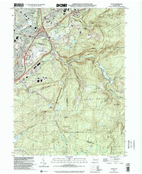
1999 Map of Avoca
USGS Topo · Published 2002About this map
The Lackawanna River corridor anchors this landscape, serving as a hub for industry and transport between Old Forge and Avoca. At the heart of the region, the Wilkes-Barre Scranton Intl Airport occupies a massive footprint on the plateau above Glendale, signifying the area's mid-century shift toward modern infrastructure. The map documents a dense network of transit, from the Pennsylvania RR and Hillside Junction to the Pennsylvania Turnpike Extension, which cuts through the valley floor.
Find a feature on this map
64 named features on this map. Tap any name to fly to it.
Don’t see what you’re looking for? This feature index may not catch every label — zoom into the map to look around manually.
Map Details
Editions of this 1999 Avoca Map
This is the sole edition of this map. No revisions or reprints were ever made.
Other maps of this area

1889 · Scranton
USGS Topo · 1:62,500

1891 · Wilkesbarre
USGS Topo · 1:62,500

1891 · Scranton
USGS Topo · 1:62,500

1893 · Pittston
USGS Topo · 1:62,500

1893 · Scranton
USGS Topo · 1:62,500

1894 · Wilkesbarre
USGS Topo · 1:62,500

1922 · Stoddartsville
USGS Topo · 1:62,500

1924 · Stoddartsville
USGS Topo · 1:62,500

1943 · Scranton
USGS Topo · 1:125,000

1943 · Stoddartsville
USGS Topo · 1:62,500