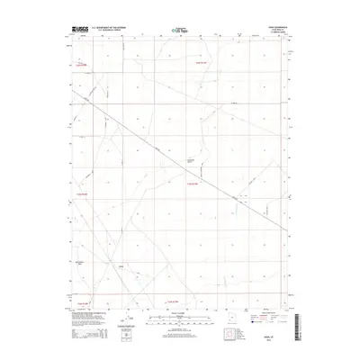
2014 Map of Avon
USGS Topo · Published 2014About this map
The Escalante Desert of Iron County defines the landscape of this 2014 survey, where the small settlement of Avon is situated among a network of rural roads and desert washes. The geography is characterized by seasonal watercourses like Iron Springs Cr and Dick Palmer Wash, which cut through the arid terrain. The diagonal path of Lund Hwy serves as the primary artery through this section of the desert, connecting the scattered homesteads and ranching areas. Local infrastructure is marked by several long-distance loops that reflect the ranching heritage of the area, including Bulloch Loop, Southern Loop, and Perkins Schoppman Loop. This map provides a clear view of the modern township and range boundaries, such as t33s r13w, showing how land is managed and partitioned in this part of southwestern Utah.
Find a feature on this map
25 named features on this map. Tap any name to fly to it.
Don’t see what you’re looking for? This feature index may not catch every label — zoom into the map to look around manually.
Map Details
Editions of this 2014 Avon Map
This is the sole edition of this map. No revisions or reprints were ever made.
Other maps of this area

1885 · St. George
USGS Topo · 1:250,000

1891 · St. George
USGS Topo · 1:250,000

1950 · Antelope Peak
USGS Topo · 1:24,000

1950 · Enoch
USGS Topo · 1:62,500

1950 · The Three Peaks
USGS Topo · 1:24,000

1950 · Avon SE
USGS Topo · 1:24,000

1951 · Avon SE
USGS Topo · 1:24,000
1951 · The Three Peaks
USGS Topo · 1:24,000

1951 · Avon
USGS Topo · 1:24,000

1951 · Avon NW
USGS Topo · 1:24,000