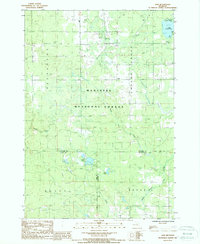
1987 Map of Axin
USGS Topo · Published 1988About this map
Manistee National Forest dominates this landscape in the mid-1980s, preserving a network of creeks and timberland across the intersection of Wexford, Lake, and Osceola Counties. The small settlements of Mitchell and Axin are centered within Cherry Grove, with the former situated near the southwest shore of Lake Mitchell. This area reflects a mid-century balance of conservation and recreation, evidenced by the designated Camp Ground, Boat Ramp, and Picnic Area near Lake Olga. A series of firebreaks cut through the forest sections, illustrating active woodland management. The map also captures several distinct watercourses, including the North Branch Pine River in the southeast corner and Negro Creek, which feeds into the larger forest hydrology. Local history markers like the Cem near Spalding Creek provide specific points of interest for genealogists tracing families in these rural townships.
Find a feature on this map
25 named features on this map. Tap any name to fly to it.
Don’t see what you’re looking for? This feature index may not catch every label — zoom into the map to look around manually.
Map Details
Editions of this 1987 Axin Map
This is the sole edition of this map. No revisions or reprints were ever made.
Other maps of this area

1933 · Luther SE
USGS Topo · 1:31,680

1933 · Luther SW
USGS Topo · 1:31,680

1933 · Luther NW
USGS Topo · 1:31,680

1954 · Traverse City
USGS Topo · 1:250,000

1956 · Mesick
USGS Topo · 1:62,500

1956 · Cadillac North
USGS Topo · 1:62,500

1957 · Cadillac South
USGS Topo · 1:62,500

1957 · Luther
USGS Topo · 1:62,500

1958 · Traverse City
USGS Topo · 1:250,000

1983 · Cadillac
USGS Topo · 1:100,000