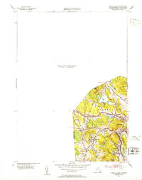
1952 Map of Ayers Village
USGS Topo · Published 1953About this map
The Merrimack River flows along the southeastern edge of this terrain, anchoring a landscape where the state line between New Hampshire and Massachusetts bisects several small communities. The 1952 revision captures the area during a period of mid-century residential growth, evidenced by the development of Graceland Park and Maple Park near the river bend. The interior is characterized by a series of prominent hills like Beebe Hill and Parsonage Hill, which hem in local water bodies such as Crystal Lake. Transportation is defined by a network of established corridors, including Ayers Village Rd and Broadway, connecting local landmarks like the Merrimack Valley Golf Club. This survey provides clear detail for researchers tracing early twentieth-century local infrastructure, from the Howe Sch to the quiet placement of Hillside Cem near West Parish.
Find a feature on this map
30 named features on this map. Tap any name to fly to it.
Don’t see what you’re looking for? This feature index may not catch every label — zoom into the map to look around manually.
Map Details
Editions of this 1952 Ayers Village Map
This is the sole edition of this map. No revisions or reprints were ever made.
Other maps of this area

1886 · Lawrence
USGS Topo · 1:62,500

1886 · Lowell
USGS Topo · 1:62,500

1888 · Haverhill
USGS Topo · 1:62,500

1888 · Lawrence
USGS Topo · 1:62,500

1890 · Haverhill
USGS Topo · 1:62,500

1893 · Lowell
USGS Topo · 1:62,500

1893 · Lawrence
USGS Topo · 1:62,500

1893 · Haverhill
USGS Topo · 1:62,500

1905 · Manchester
USGS Topo · 1:62,500

1918 · Lowell
USGS Topo · 1:62,500