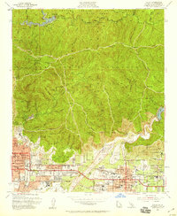
1953 Map of Azusa
USGS Topo · Published 1959About this map
The San Gabriel Mountains dominate the landscape north of the post-war expansion in Azusa, Duarte, and Monrovia. This 1950s record shows the region's sophisticated water management system, including Cogswell Dam, Morris Dam, and the Santa Fe Flood Control Basin. Educational and institutional landmarks are particularly well-represented, from the City of Hope Natl Medical Center to the Pacific Bible College and the Citrus Union High Sch and Jr College.
Find a feature on this map
96 named features on this map. Tap any name to fly to it.
Don’t see what you’re looking for? This feature index may not catch every label — zoom into the map to look around manually.
Map Details
Editions of this 1953 Azusa Map
2 editions found
Other maps of this area

1894 · Los Angeles
USGS Topo · 1:62,500

1894 · Pomona
USGS Topo · 1:62,500

1896 · Pasadena
USGS Topo · 1:62,500

1897 · Pomona
USGS Topo · 1:62,500

1898 · Pomona
USGS Topo · 1:62,500

1900 · Pasadena
USGS Topo · 1:62,500

1900 · Tujunga
USGS Topo · 1:62,500

1900 · Los Angeles
USGS Topo · 1:62,500

1901 · Southern California Sheet No. 1
USGS Topo · 1:250,000

1903 · Rock Creek
USGS Topo · 1:62,500