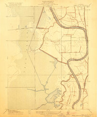
1916 Map of Babel Slough
USGS Topo · Published 1916About this map
The Sacramento River carves a winding path through this 1906 survey of the Sacramento Valley, defining the border between Sacramento and Yolo counties. This river-centric landscape reveals an era of intense reclamation and water management, evidenced by the expansive Yolo Basin and a network of drainage infrastructure like the Oakland Antioch and Eastern Canal and Pacific Drainage Canal. Small riverside settlements including Clarksburg, Freeport, and Lisbon serve as focal points for local commerce and transport.
Find a feature on this map
25 named features on this map. Tap any name to fly to it.
Don’t see what you’re looking for? This feature index may not catch every label — zoom into the map to look around manually.
Map Details
Editions of this 1916 Babel Slough Map
This is the sole edition of this map. No revisions or reprints were ever made.
Other maps of this area

1891 · Sacramento
USGS Topo · 1:125,000

1892 · Sacramento
USGS Topo · 1:125,000

1893 · Sacramento
USGS Topo · 1:125,000

1894 · Lodi
USGS Topo · 1:125,000

1902 · Fairoaks
USGS Topo · 1:62,500

1907 · Davisville
USGS Topo · 1:62,500

1908 · Courtland
USGS Topo · 1:62,500

1909 · Florin
USGS Topo · 1:31,680

1910 · Bruceville
USGS Topo · 1:31,680

1911 · Brighton
USGS Topo · 1:31,680