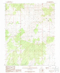
1989 Map of Baboon Peak
USGS Topo · Published 1989About this map
Baboon Peak and the high ridges of the Black Mountains dominate this 1980s landscape in Iron County. The terrain is defined by the broad expanses of Horse Valley and Little Horse Valley, which are separated by a dramatic topographical pinch point known as The Narrows. Water management and livestock history are evident through scattered features such as Marshall Pond, Baboon Seep, and a Corral, indicating a landscape utilized for ranching despite its arid character. The presence of Radio Facilities near the peak and several wells across the valleys suggests a transition toward modern infrastructure. Local drainages like Jacko Wash and Lost Spring Hollow carve through the southern slopes, providing a detailed look at the hydraulic patterns of this high-desert region before late-twentieth-century developments altered the area.
Find a feature on this map
19 named features on this map. Tap any name to fly to it.
Don’t see what you’re looking for? This feature index may not catch every label — zoom into the map to look around manually.
Map Details
Editions of this 1989 Baboon Peak Map
This is the sole edition of this map. No revisions or reprints were ever made.
Other maps of this area

1885 · St. George
USGS Topo · 1:250,000

1885 · Beaver
USGS Topo · 1:250,000

1886 · Kanab
USGS Topo · 1:250,000

1891 · St. George
USGS Topo · 1:250,000

1950 · Enoch
USGS Topo · 1:62,500

1950 · Enoch NE
USGS Topo · 1:24,000
1952 · Enoch NW
USGS Topo · 1:24,000

1952 · Enoch NE
USGS Topo · 1:24,000

1953 · Ninemile Knoll
USGS Topo · 1:24,000

1953 · Minersville
USGS Topo · 1:24,000