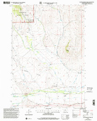
1997 Map of Bachelor Mountain
USGS Topo · Published 2002About this map
The Lewis and Clark National Historic Trail skirts the southern edge of this high-elevation Montana landscape, following the route through what is now the Beaverhead National Forest. This 1997 revision documents a territory defined by ranching and livestock movement, centered on the broad expanse of Horse Prairie and the aptly named Poverty Flats. Isolated outposts like Hughes Ranch and Pierce Ranch are the primary markers of habitation, situated near the confluence of several mountain drainages including Bloody Dick Creek and Dunlap Creek. The presence of multiple landing strips and a landing strip north of Browns Canyon suggests the necessity of light aircraft for managing these remote grazing lands. The topography is anchored by the 7,563-foot summit of Bachelor Mountain, providing a vantage over the complex network of creeks that feed the Dillon Ranger District.
Find a feature on this map
30 named features on this map. Tap any name to fly to it.
Don’t see what you’re looking for? This feature index may not catch every label — zoom into the map to look around manually.
Map Details
Editions of this 1997 Bachelor Mountain Map
This is the sole edition of this map. No revisions or reprints were ever made.
Other maps of this area

1955 · Dubois
USGS Topo · 1:250,000

1955 · Dillon
USGS Topo · 1:250,000

1957 · Dillon
USGS Topo · 1:250,000

1958 · Dubois
USGS Topo · 1:250,000

1958 · Dillon
USGS Topo · 1:250,000

1959 · Grant
USGS Topo · 1:62,500

1962 · Dillon
USGS Topo · 1:250,000

1965 · Dillon
USGS Topo · 1:250,000

1965 · Jeff Davis Peak
USGS Topo · 1:24,000
1965 · Hansen Ranch
USGS Topo · 1:24,000