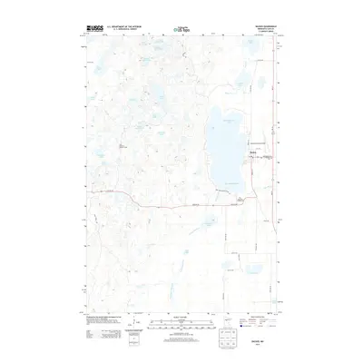
2013 Map of Backus
USGS Topo · Published 2013About this map
Backus serves as the central hub of this Cass County landscape, situated along the eastern shore of Pine Mountain Lake. The town's layout is defined by the intersection of state routes and residential streets like Washburn Ave E and Front St S, where local landmarks such as the Evergreen Cem and the Backus Municipal Airport are established. Beyond the town limits, the terrain is characterized by a dense network of glacial water bodies and wetlands, including the uniquely named Sleepy Island Lake, Trestle Lake, and Ox Camp Lake. The drainage system is anchored by the South Fork Pine River, which meanders through the southern half of the quadrangle. Recreational and forestry interests are evident in the presence of the Pine Mountain Lookout Tower and the Pine Mountain Campground, while remote paths like the Bull Moose Trl suggest a landscape used for both timber management and backwoods navigation.
Find a feature on this map
46 named features on this map. Tap any name to fly to it.
Don’t see what you’re looking for? This feature index may not catch every label — zoom into the map to look around manually.
Map Details
Editions of this 2013 Backus Map
This is the sole edition of this map. No revisions or reprints were ever made.
Other maps of this area

1919 · Leader
USGS Topo · 1:62,500

1953 · Brainerd
USGS Topo · 1:250,000

1957 · Brainerd
USGS Topo · 1:250,000

1958 · Brainerd
USGS Topo · 1:250,000

1959 · Pine River
USGS Topo · 1:24,000

1965 · Brainerd
USGS Topo · 1:250,000

1970 · Spider Lake
USGS Topo · 1:24,000

1970 · Backus
USGS Topo · 1:24,000

1970 · Hackensack
USGS Topo · 1:24,000
1970 · Bungo Creek
USGS Topo · 1:24,000