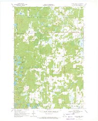
1970 Map of Bungo Creek
USGS Topo · Published 1972About this map
The Foot Hills State Forest dominates this northern landscape, where an intricate network of wetlands and small glacial lakes defines the topography of Cass County. During the early 1970s, this region was characterized by its timber resources and isolated public infrastructure, such as the centrally located Townhall 1364. The drainage pattern is complex, with Bungo Creek and Dabill Creek winding through the forest floor toward the South Fork Pine River in the northeast.
Find a feature on this map
36 named features on this map. Tap any name to fly to it.
Don’t see what you’re looking for? This feature index may not catch every label — zoom into the map to look around manually.
Map Details
Editions of this 1970 Bungo Creek Map
This is the sole edition of this map. No revisions or reprints were ever made.
Other maps of this area

1919 · Leader
USGS Topo · 1:62,500

1953 · Brainerd
USGS Topo · 1:250,000

1957 · Brainerd
USGS Topo · 1:250,000

1958 · Brainerd
USGS Topo · 1:250,000

1959 · Pine River
USGS Topo · 1:24,000

1959 · Pine River SW
USGS Topo · 1:24,000

1965 · Brainerd
USGS Topo · 1:250,000

1970 · Spider Lake
USGS Topo · 1:24,000

1970 · Backus
USGS Topo · 1:24,000
1970 · Mildred
USGS Topo · 1:24,000