
1959 Map of Pine River SW
USGS Topo · Published 1960About this map
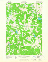
Stony Brook meanders through the central terrain of Cass County in this late 1950s survey, illustrating a landscape defined by its glacial lakes and rural community nodes. The settlement of Mayo and the nearby Mayo Creek Cem serve as focal points for local history, while the rural schoolhouse at Stony Brook Sch and several country churches, including Bethlehem Ch and Grace Ch, mark the social fabric of the era. To the southeast, the Village Boundary of Lake Shore touches the edges of Upper Loon Lake and Loon Lake, showing the early footprint of this lakeside community. The drainage patterns of Home Brook and Cory Brook reveal the low-lying wetlands and dense woodlands that characterized the region before further modern development, providing a clear record for those researching the environmental or genealogical history of this Minnesota lake country.
Find a feature on this map
17 named features on this map. Tap any name to fly to it.
Don’t see what you’re looking for? This feature index may not catch every label — zoom into the map to look around manually.
Map Details
Editions of this 1959 Pine River SW Map
2 editions found
Other maps of this area

1916 · Pillager
USGS Topo · 1:62,500

1919 · Pillager
USGS Topo · 1:62,500

1919 · Leader
USGS Topo · 1:62,500

1953 · Brainerd
USGS Topo · 1:250,000

1957 · Brainerd
USGS Topo · 1:250,000

1958 · Brainerd
USGS Topo · 1:250,000

1959 · Nisswa
USGS Topo · 1:24,000

1959 · Pine River
USGS Topo · 1:24,000

1959 · Jenkins
USGS Topo · 1:24,000

1965 · Brainerd
USGS Topo · 1:250,000