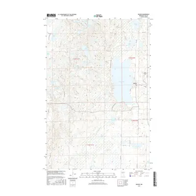
2016 Map of Backus
USGS Topo · Published 2016About this map
Pine Mountain Lake dominates the central landscape of this Cass County region, with the settlement of Backus established along its eastern shore. The town is a focal point for local travel and commerce, supported by the Backus Municipal Airport and a network of secondary roads including Wood St and Point Rd. The surrounding terrain is a complex mosaic of glacial water bodies and wetlands, featuring evocatively named features such as Sleepy Island Lake, Ox Camp Lake, and Cranberry Lake. To the south, the S Fork Pine River meanders through the lowlands near Abel Lake, while the Evergreen Cemetery sits just south of the main town site. The presence of Second Trestle Lake and names like Bull Moose Trl suggest a history tied to both timber transport and the enduring wilderness character of northern Minnesota.
Find a feature on this map
52 named features on this map. Tap any name to fly to it.
Don’t see what you’re looking for? This feature index may not catch every label — zoom into the map to look around manually.
Map Details
Editions of this 2016 Backus Map
This is the sole edition of this map. No revisions or reprints were ever made.
Other maps of this area

1919 · Leader
USGS Topo · 1:62,500

1953 · Brainerd
USGS Topo · 1:250,000

1957 · Brainerd
USGS Topo · 1:250,000

1958 · Brainerd
USGS Topo · 1:250,000

1959 · Pine River
USGS Topo · 1:24,000

1965 · Brainerd
USGS Topo · 1:250,000

1970 · Spider Lake
USGS Topo · 1:24,000

1970 · Backus
USGS Topo · 1:24,000

1970 · Hackensack
USGS Topo · 1:24,000
1970 · Bungo Creek
USGS Topo · 1:24,000