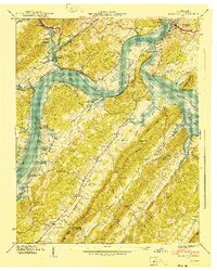
1940 Map of Bacon Gap
USGS Topo · Published 1940About this map
Kingston sits at the strategic confluence of the Tennessee River and the Clinch River, a landscape on the verge of total transformation during this 1940 survey. Blue stipple marking the Watts Bar Reservoir indicates the immense territory slated for submergence, including riverbank sites like Hood Landing and James Ferry. The map documents the existing river-and-rail economy, with the Southern railroad tracking the Tennessee's curves and historic thoroughfares like the Walton Road and Broadway of America cutting through the terrain.
Find a feature on this map
68 named features on this map. Tap any name to fly to it.
Don’t see what you’re looking for? This feature index may not catch every label — zoom into the map to look around manually.
Map Details
Editions of this 1940 Bacon Gap Map
2 editions found
Other maps of this area

1887 · Kingston
USGS Topo · 1:125,000

1891 · Kingston
USGS Topo · 1:125,000

1893 · Kingston
USGS Topo · 1:125,000

1895 · Loudon
USGS Topo · 1:125,000

1935 · Rockwood
USGS Topo · 1:24,000

1935 · Elverton
USGS Topo · 1:24,000

1935 · Harriman
USGS Topo · 1:24,000

1935 · Philadelphia
USGS Topo · 1:24,000

1936 · Cave Creek
USGS Topo · 1:24,000

1936 · Cardiff
USGS Topo · 1:24,000