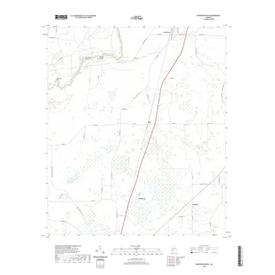
2020 Map of Baconton South
USGS Topo · Published 2020About this map
Camilla anchors the southern portion of this landscape, situated at the intersection of several key routes including Old State Rte 3 and Old Newton Rd. The north is dominated by the winding path of the Flint River, which creates distinctive geographical features like Horseshoe Bend and Prossers Island along the Baker Co and Mitchell Co boundary. The terrain is dotted with numerous wetlands and small water bodies such as Rock Pond, Rock Lake, and The Flat, illustrating the hydrologic character of this part of Georgia. Rural life is evidenced by the inclusion of Creek Cem and China Grove Cem, while smaller settlements like Flint and Adelaide suggest the distribution of historic local communities. The presence of Culpepper Spring and Walton Spring highlights the natural water sources that have long shaped land use in this region.
Find a feature on this map
48 named features on this map. Tap any name to fly to it.
Don’t see what you’re looking for? This feature index may not catch every label — zoom into the map to look around manually.
Map Details
Editions of this 2020 Baconton South Map
This is the sole edition of this map. No revisions or reprints were ever made.
Other maps of this area

1953 · Dothan
USGS Topo · 1:250,000

1954 · Dothan
USGS Topo · 1:250,000

1955 · Dothan
USGS Topo · 1:250,000

1956 · Baconton
USGS Topo · 1:62,500

1956 · Newton
USGS Topo · 1:62,500

1971 · Camilla
USGS Topo · 1:24,000

1971 · Cotton
USGS Topo · 1:24,000
1971 · Branchville
USGS Topo · 1:24,000
1974 · Putney
USGS Topo · 1:24,000
1974 · Baconton South
USGS Topo · 1:24,000