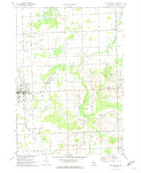
1970 Map of Bad Axe East
USGS Topo · Published 1973About this map
Agricultural patterns and utility infrastructure dominate the landscape of Huron County as it appeared in the late 1960s. The city of Bad Axe stands as a focal point, with its distinctive Chesapeake and Ohio RR line running through the town and southward past the Huron County Memorial Airport. The map highlights a rural economy transition, visible in the numerous Gravel Pits and a solitary Oil Well located near Townhall.
Find a feature on this map
42 named features on this map. Tap any name to fly to it.
Don’t see what you’re looking for? This feature index may not catch every label — zoom into the map to look around manually.
Map Details
Editions of this 1970 Bad Axe East Map
This is the sole edition of this map. No revisions or reprints were ever made.
Other maps of this area

1954 · Flint
USGS Topo · 1:250,000

1958 · Flint
USGS Topo · 1:250,000

1963 · New Greenleaf
USGS Topo · 1:24,000

1963 · Ubly
USGS Topo · 1:24,000

1963 · Minden City
USGS Topo · 1:24,000

1970 · Kinde East
USGS Topo · 1:24,000

1970 · Redman
USGS Topo · 1:24,000

1970 · Kinde West
USGS Topo · 1:24,000

1970 · Bad Axe West
USGS Topo · 1:24,000

1970 · Bad Axe SE
USGS Topo · 1:24,000