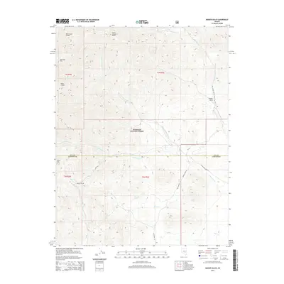
2014 Map of Badger Gulch
USGS Topo · Published 2014About this map
The Humboldt National Forest dominates the high-elevation landscape of this 2014 survey, where the Quinn Canyon Range defines the topography of eastern Nevada. The map captures a transition between the county lines of Nye and Lincoln counties, marking prominent peaks such as Stairstep Mtn and Worthington Peak. The drainages of N Fork Cottonwood Cr and S Fork Cottonwood Cr carve through the terrain, illustrating the critical water distribution in this arid environment. Strategic water points including Mustang Spring, Barton Spring, and Cedar Spring are meticulously recorded, alongside historical travel routes like the Barton Creek Rd and McCutchen Rd. This edition provides a clear view of the ranching and resource management corridors that persist in the Great Basin highlands.
Find a feature on this map
34 named features on this map. Tap any name to fly to it.
Don’t see what you’re looking for? This feature index may not catch every label — zoom into the map to look around manually.
Map Details
Editions of this 2014 Badger Gulch Map
This is the sole edition of this map. No revisions or reprints were ever made.
Other maps of this area

1942 · Penoyer Valley
USGS Topo · 1:125,000

1954 · Caliente
USGS Topo · 1:250,000

1956 · Lund
USGS Topo · 1:250,000

1959 · Caliente
USGS Topo · 1:250,000

1960 · Lund
USGS Topo · 1:250,000

1985 · Adaven
USGS Topo · 1:24,000

1985 · Worthington Peak
USGS Topo · 1:24,000

1985 · McCutchen Spring
USGS Topo · 1:24,000
1985 · Goat Ranch Springs
USGS Topo · 1:24,000
1985 · Big Creek Ranch
USGS Topo · 1:24,000