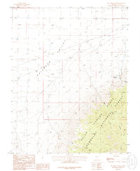
1985 Map of Big Creek Ranch
USGS Topo · Published 1986About this map
Railroad Valley dominates the western half of this 1980s survey, illustrating the vast, arid basin floor before it rises sharply into the high country of the Humboldt National Forest. The transition from the valley floor to the mountains is defined by deep drainage systems, including Deep Creek Canyon and Dry Canyon, which funnel seasonal runoff toward the desert sinks. The Big Creek Ranch stands as a lonely outpost of human activity along the eastern edge, situated near where Big Creek emerges from the canyon mouth.
Find a feature on this map
13 named features on this map. Tap any name to fly to it.
Don’t see what you’re looking for? This feature index may not catch every label — zoom into the map to look around manually.
Map Details
Editions of this 1985 Big Creek Ranch Map
This is the sole edition of this map. No revisions or reprints were ever made.
Other maps of this area

1956 · Lund
USGS Topo · 1:250,000

1960 · Lund
USGS Topo · 1:250,000

1964 · Troy Canyon
USGS Topo · 1:62,500

1968 · The Wall
USGS Topo · 1:62,500
1968 · The Wall SE
USGS Topo · 1:24,000
1968 · The Wall SW
USGS Topo · 1:24,000
1985 · Eds Well
USGS Topo · 1:24,000
1985 · Goat Ranch Well
USGS Topo · 1:24,000
1985 · Goat Ranch Springs
USGS Topo · 1:24,000
1985 · Badger Gulch
USGS Topo · 1:24,000