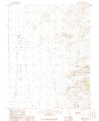
1985 Map of Eds Well
USGS Topo · Published 1986About this map
Railroad Valley spreads across the western portion of this 1981 survey, a vast low-lying basin that contrasts sharply with the high ridges of the Quinn Canyon Range to the east. At the base of the mountains, Eds Well serves as a critical point of water in this arid landscape, located near the foot of Eds Hill 6645. The map documents a rugged interior with limited human imprints beyond a lone Prospect and a network of 4 WD tracks navigating the drainage channels. Along the county line separating Nye and Lincoln Counties, the terrain ascends toward Red Bluff Spring, illustrating the sparse but essential water sources that dictated movement through this high desert environment during the late twentieth century.
Find a feature on this map
8 named features on this map. Tap any name to fly to it.
Don’t see what you’re looking for? This feature index may not catch every label — zoom into the map to look around manually.
Map Details
Editions of this 1985 Eds Well Map
This is the sole edition of this map. No revisions or reprints were ever made.
Other maps of this area

1908 · Kawich
USGS Topo · 1:250,000

1942 · Reveille Peak
USGS Topo · 1:125,000

1942 · Penoyer Valley
USGS Topo · 1:125,000

1952 · Reveille Peak
USGS Topo · 1:62,500

1954 · Caliente
USGS Topo · 1:250,000

1954 · Goldfield
USGS Topo · 1:250,000

1955 · Goldfield
USGS Topo · 1:250,000

1956 · Lund
USGS Topo · 1:250,000

1956 · Tonopah
USGS Topo · 1:250,000

1958 · Goldfield
USGS Topo · 1:250,000