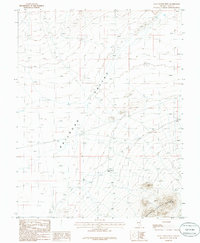
1985 Map of Goat Ranch Well
USGS Topo · Published 1986About this map
Railroad Valley dominates the central portion of this mid-1980s survey, illustrating a typical Great Basin landscape of wide basins and sudden mountain ranges. The eastern edge of the map rises into the Quinn Canyon Range, where the terrain ascends towards Red Hill. This area is characterized by sparse water resources, highlighted by the centrally located Goat Ranch Well, which serves as a critical landmark in an otherwise arid expanse. Small-scale industrial activity is evidenced by a Gravel Pit located north of the well. The map reveals the intricate network of unimproved roads and trails that connected these remote ranching and resource sites during the late twentieth century, showing how human presence adapted to the vast, open geography of Nye County.
Find a feature on this map
6 named features on this map. Tap any name to fly to it.
Don’t see what you’re looking for? This feature index may not catch every label — zoom into the map to look around manually.
Map Details
Editions of this 1985 Goat Ranch Well Map
This is the sole edition of this map. No revisions or reprints were ever made.
Other maps of this area

1956 · Lund
USGS Topo · 1:250,000

1956 · Tonopah
USGS Topo · 1:250,000

1959 · Tonopah
USGS Topo · 1:250,000

1960 · Lund
USGS Topo · 1:250,000

1962 · Tonopah
USGS Topo · 1:250,000

1967 · Lunar Crater
USGS Topo · 1:62,500
1967 · Chuck Wagon Flat
USGS Topo · 1:24,000
1968 · Reveille
USGS Topo · 1:62,500

1968 · The Wall
USGS Topo · 1:62,500
1968 · The Wall SE
USGS Topo · 1:24,000