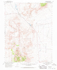
1968 Map of Reveille
USGS Topo · Published 1971About this map
Reveille (Site) serves as a focal point for this 1968 topographic study, positioned near the southern reaches of the Reveille Range. The landscape is defined by its mining heritage, with the New Reveille Mine, Gila Mine, and Last Burro Mine carved into the mountainsides alongside various prospects and ruins. Water, a critical resource in this arid environment, is meticulously documented at Cane Spring, Hyde Spring, and the Echo Canyon Reservoir. To the north, the Twin Springs Ranch sits at the junction of the Hot Creek Valley and the Pancake Range, where a slough and seeps provide moisture for the valley floor. The map highlights a network of jeep trails and the Nyala Road, connecting these isolated mineral works to the broader expanse of Railroad Valley.
Find a feature on this map
41 named features on this map. Tap any name to fly to it.
Don’t see what you’re looking for? This feature index may not catch every label — zoom into the map to look around manually.
Map Details
Editions of this 1968 Reveille Map
2 editions found
Other maps of this area

1908 · Kawich
USGS Topo · 1:250,000

1942 · Reveille Peak
USGS Topo · 1:125,000

1942 · Penoyer Valley
USGS Topo · 1:125,000

1952 · Kawich Peak
USGS Topo · 1:62,500

1952 · Reveille Peak
USGS Topo · 1:62,500

1954 · Caliente
USGS Topo · 1:250,000

1954 · Goldfield
USGS Topo · 1:250,000

1955 · Goldfield
USGS Topo · 1:250,000

1956 · Lund
USGS Topo · 1:250,000

1956 · Tonopah
USGS Topo · 1:250,000