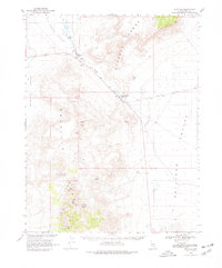
1968 Map of Reveille
USGS Topo · Published 1978About this map
Reveille Range dominates the western half of this Nevada landscape, where high-desert mining activity left a permanent mark on the terrain. Several former mining camps and operations are documented here, including the Reveille and New Reveille sites, alongside workings at the Lost Burro Mine, Gila Mine, and Kletzke Mine. The map captures a high-desert interior where water sources like Twin Springs, Hyde Spring, and Cane Spring were vital for both livestock at the Twin Springs Ranch and for the early prospectors searching the mineral-rich hills. To the east, the flat expanse of Railroad Valley contrasts with the jagged topography of the Pancake Range, while the Echo Canyon Slough cuts a distinct path toward the Echo Canyon Reservoir.
Find a feature on this map
37 named features on this map. Tap any name to fly to it.
Don’t see what you’re looking for? This feature index may not catch every label — zoom into the map to look around manually.
Map Details
Editions of this 1968 Reveille Map
2 editions found
Other maps of this area

1908 · Kawich
USGS Topo · 1:250,000

1942 · Reveille Peak
USGS Topo · 1:125,000

1942 · Penoyer Valley
USGS Topo · 1:125,000

1952 · Kawich Peak
USGS Topo · 1:62,500

1952 · Reveille Peak
USGS Topo · 1:62,500

1954 · Caliente
USGS Topo · 1:250,000

1954 · Goldfield
USGS Topo · 1:250,000

1955 · Goldfield
USGS Topo · 1:250,000

1956 · Lund
USGS Topo · 1:250,000

1956 · Tonopah
USGS Topo · 1:250,000