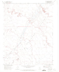
1968 Map of The Wall SE
USGS Topo · Published 1972About this map
Railroad Valley dominates the topography of this Nye County landscape, where the wide desert floor is marked by essential water sources and signs of mid-century exploration. Mapped in 1968 in cooperation with the Atomic Energy Commission, the sheet highlights scattered water points like Abel Spring and Feroy Well, which served as critical landmarks in an otherwise arid expanse. In the southern portion of the quadrangle, the presence of Drill Holes and a Well near the boundary of R. 54 E. and R. 55 E. reflects the period's geological and energy-related survey activities. The map provides a precise record of the desert's drainage patterns and elevations, documenting the specific locations of isolated infrastructure within the Great Basin's expansive basin-and-range terrain.
Find a feature on this map
7 named features on this map. Tap any name to fly to it.
Don’t see what you’re looking for? This feature index may not catch every label — zoom into the map to look around manually.
Map Details
Editions of this 1968 The Wall SE Map
This is the sole edition of this map. No revisions or reprints were ever made.
Other maps of this area

1956 · Lund
USGS Topo · 1:250,000

1960 · Lund
USGS Topo · 1:250,000

1964 · Troy Canyon
USGS Topo · 1:62,500

1968 · The Wall
USGS Topo · 1:62,500
1968 · The Wall
USGS Topo · 1:24,000
1968 · The Wall SW
USGS Topo · 1:24,000
1968 · The Wall NE
USGS Topo · 1:24,000
1985 · Goat Ranch Well
USGS Topo · 1:24,000
1985 · Big Creek Ranch
USGS Topo · 1:24,000
1985 · Nyala
USGS Topo · 1:24,000