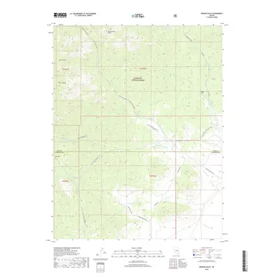
2018 Map of Badger Gulch
USGS Topo · Published 2018About this map
The Quinn Canyon Range dominates the high-elevation landscape of this 2018 survey, which straddles the boundary between Nye and Lincoln Counties. Much of the terrain lies within the Humboldt National Forest, characterized by deep incisions like Water Canyon and the prominent heights of Stairstep Mtn. A network of unpaved forest roads and primitive trails, such as Cedar Spring Trail and Mccutchen Rd, provides the only access through this isolated interior.
Find a feature on this map
30 named features on this map. Tap any name to fly to it.
Don’t see what you’re looking for? This feature index may not catch every label — zoom into the map to look around manually.
Map Details
Editions of this 2018 Badger Gulch Map
This is the sole edition of this map. No revisions or reprints were ever made.
Other maps of this area

1942 · Penoyer Valley
USGS Topo · 1:125,000

1954 · Caliente
USGS Topo · 1:250,000

1956 · Lund
USGS Topo · 1:250,000

1959 · Caliente
USGS Topo · 1:250,000

1960 · Lund
USGS Topo · 1:250,000

1985 · Adaven
USGS Topo · 1:24,000

1985 · Worthington Peak
USGS Topo · 1:24,000

1985 · McCutchen Spring
USGS Topo · 1:24,000
1985 · Goat Ranch Springs
USGS Topo · 1:24,000
1985 · Big Creek Ranch
USGS Topo · 1:24,000