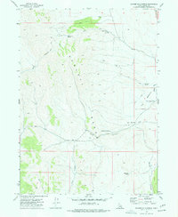
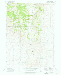
1973 Map of Badger Hole Spring
USGS Topo · Published 1977About this map
The high desert landscape of the Sublett Range is defined here by a network of essential water sources and seasonal grazing grounds. This 1973 field-checked survey reveals the livestock-oriented economy of the era, centered on the Salyer Cow Camp and numerous family-named water features like Huffman Springs and Salyer Spring. The rugged topography is etched with Jeep Trails that connect these remote outposts across the The Meadows Divide.
Find a feature on this map
18 named features on this map. Tap any name to fly to it.
Don’t see what you’re looking for? This feature index may not catch every label — zoom into the map to look around manually.
Map Details
Editions of this 1973 Badger Hole Spring Map
This is the sole edition of this map. No revisions or reprints were ever made.
Other maps of this area

1954 · Pocatello
USGS Topo · 1:250,000

1958 · Pocatello
USGS Topo · 1:250,000

1973 · Juniper
USGS Topo · 1:24,000

1973 · The Cove
USGS Topo · 1:24,000

1973 · Sublett Troughs
USGS Topo · 1:24,000
1973 · Roy
USGS Topo · 1:24,000

1973 · Black Pine
USGS Topo · 1:24,000
1973 · Stone
USGS Topo · 1:24,000
1973 · Holbrook
USGS Topo · 1:24,000
1973 · Cedarhill
USGS Topo · 1:24,000