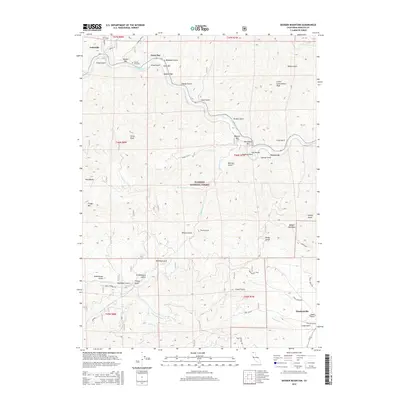
2015 Map of Badger Mountain
USGS Topo · Published 2015About this map
The Klamath River carves a deep path through this portion of the Klamath National Forest, where a series of river bars such as Kanaka Bar, Swiss Bar, and Masonic Bar suggest a history of riparian activity and early settlement. Near the river, the Kanaka Cemetery serves as a silent witness to the people who once worked these drainages. To the north, Gottsville sits near the river's edge, while the southern landscape is defined by the settlement of Hawkinsville and the winding course of the Yreka Ditch. The terrain is exceptionally fractured by numerous gulches, including Deadman Gulch, Schoolhouse Gulch, and Garvey Gulch, indicating a complex drainage system feeding into the main river channel. High points like China Peak, Craggy Mtn, and Badger Mountain provide significant vertical relief, overlooking a network of forest roads including Middle Humbug Rd and Long Gulch Rd.
Find a feature on this map
65 named features on this map. Tap any name to fly to it.
Don’t see what you’re looking for? This feature index may not catch every label — zoom into the map to look around manually.
Map Details
Editions of this 2015 Badger Mountain Map
This is the sole edition of this map. No revisions or reprints were ever made.
Other maps of this area

1886 · Shasta
USGS Topo · 1:250,000

1894 · Shasta
USGS Topo · 1:250,000

1922 · Shasta Valley Sheet No 3
USGS Topo · 1:24,000

1932 · Yreka
USGS Topo · 1:96,000

1939 · Yreka
USGS Topo · 1:125,000

1948 · Weed
USGS Topo · 1:250,000

1950 · Weed
USGS Topo · 1:250,000

1954 · Yreka
USGS Topo · 1:62,500

1955 · Condrey Mtn
USGS Topo · 1:62,500
1955 · Hornbrook
USGS Topo · 1:62,500