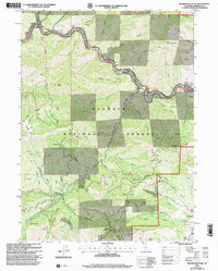
2001 Map of Badger Mountain
USGS Topo · Published 2004About this map
The Klamath River, designated here as a Wild and Scenic River, carves a deep path through the Klamath National Forest at the turn of the 21st century. This northern Siskiyou County landscape is defined by its historic gold mining legacy, evidenced by numerous prospects, tailings, and named claims like the Indian Girl Mine, Siskiyou Mine, and Mone Mine. The river's winding course is marked by several bars, including Swiss Bar, Kanaka Bar, and Stalman Bar, which reflect the area's diverse ethnic mining history.
Find a feature on this map
76 named features on this map. Tap any name to fly to it.
Don’t see what you’re looking for? This feature index may not catch every label — zoom into the map to look around manually.
Map Details
Editions of this 2001 Badger Mountain Map
This is the sole edition of this map. No revisions or reprints were ever made.
Other maps of this area

1886 · Shasta
USGS Topo · 1:250,000

1894 · Shasta
USGS Topo · 1:250,000

1922 · Shasta Valley Sheet No 3
USGS Topo · 1:24,000

1932 · Yreka
USGS Topo · 1:96,000

1939 · Yreka
USGS Topo · 1:125,000

1948 · Weed
USGS Topo · 1:250,000

1950 · Weed
USGS Topo · 1:250,000

1954 · Yreka
USGS Topo · 1:62,500

1955 · Condrey Mtn
USGS Topo · 1:62,500
1955 · Hornbrook
USGS Topo · 1:62,500