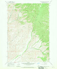
1966 Map of Badger Spring Gulch
USGS Topo · Published 1970About this map
Salmon National Forest dominates this mid-1960s survey of Idaho's high country, where the landscape is defined by a dense network of drainage systems feeding into Carmen Creek. The map documents the intricate geography of the region, noting numerous landmarks such as Gold Star Gulch, Badger Basin, and the winding Badger Spring Gulch.
Find a feature on this map
19 named features on this map. Tap any name to fly to it.
Don’t see what you’re looking for? This feature index may not catch every label — zoom into the map to look around manually.
Map Details
Editions of this 1966 Badger Spring Gulch Map
2 editions found
Other maps of this area

1950 · Salmon
USGS Topo · 1:62,500

1951 · Salmon
USGS Topo · 1:62,500

1955 · Dillon
USGS Topo · 1:250,000

1956 · Goldstone Mtn
USGS Topo · 1:62,500

1957 · Dillon
USGS Topo · 1:250,000

1958 · Dillon
USGS Topo · 1:250,000

1962 · Dillon
USGS Topo · 1:250,000

1965 · Dillon
USGS Topo · 1:250,000

1966 · Badger Spring Gulch
USGS Topo · 1:24,000

1966 · Shewag Lake
USGS Topo · 1:24,000