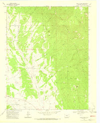
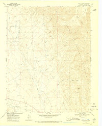
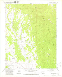
1969 Map of Badito Cone
USGS Topo · Published 1973About this map
Turkey Creek and its many tributaries, including Maes Creek and Gomez Creek, define the drainage patterns of this high-altitude landscape in Huerfano County. This 1969 field-checked survey highlights the transition from the San Isabel National Forest, which dominates the northern and eastern portions of the map, to the lower agricultural lands along the Huerfano River. Local history and genealogy are preserved in the locations of the Cisneros Cem and Maes Creek Cem, while landmarks like Badito Cone, Santana Butte, and the Arroyo Hondo provide prominent navigational points. The map documents the water infrastructure of the era, from the Huerfano Ditch to several remote water tanks and the St Jude Spring. Transportation is limited to rugged routes like the Santana Trail and Apache Trail, reflecting the area's isolation and reliance on livestock and water rights.
Find a feature on this map
25 named features on this map. Tap any name to fly to it.
Don’t see what you’re looking for? This feature index may not catch every label — zoom into the map to look around manually.
Map Details
Editions of this 1969 Badito Cone Map
3 editions found
Other maps of this area

1889 · Huerfano Park
USGS Topo · 1:125,000

1891 · Walsenburg
USGS Topo · 1:125,000

1892 · Huerfano Park
USGS Topo · 1:125,000

1894 · Walsenburg
USGS Topo · 1:125,000

1897 · Walsenburg
USGS Topo · 1:125,000

1900 · Walsenburg
USGS Topo · 1:125,000

1954 · Trinidad
USGS Topo · 1:250,000

1955 · Trinidad
USGS Topo · 1:250,000

1958 · Trinidad
USGS Topo · 1:250,000

1959 · Trinidad
USGS Topo · 1:250,000