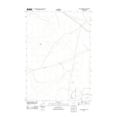
2012 Map of Badlands Hills
USGS Topo · Published 2012About this map
Badland Hills dominates the western portion of this high plains landscape in Park County, where the terrain is marked by the complex water management systems of the Bighorn Basin. The map illustrates a network of human-made water features essential to local agriculture and livestock, including the West Fork Sand Coulee Reservoir and Three Falls Reservoir. To the southeast, the influence of the Shoshone Project is evident through the Heart Mountain Canal and specialized irrigation structures like Lateral H-141. The layout of rural infrastructure is defined by a grid of numbered roads such as Road 22 and Lane 9, alongside the meandering path of Little Sand Coulee Rd, which follows the natural drainages of the Alkali Cr Patch.
Find a feature on this map
15 named features on this map. Tap any name to fly to it.
Don’t see what you’re looking for? This feature index may not catch every label — zoom into the map to look around manually.
Map Details
Editions of this 2012 Badlands Hills Map
This is the sole edition of this map. No revisions or reprints were ever made.
Other maps of this area

1949 · Cody
USGS Topo · 1:62,500

1950 · Clark
USGS Topo · 1:62,500

1951 · Cody
USGS Topo · 1:62,500

1955 · Cody
USGS Topo · 1:250,000

1958 · Cody
USGS Topo · 1:250,000

1962 · Cody
USGS Topo · 1:250,000

1966 · Elk Basin SW
USGS Topo · 1:24,000

1966 · Elk Basin NW
USGS Topo · 1:24,000
1966 · Vocation
USGS Topo · 1:24,000

1980 · Cody
USGS Topo · 1:100,000