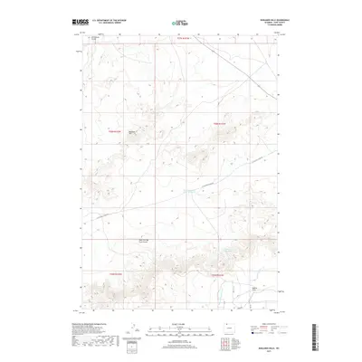
2017 Map of Badlands Hills
USGS Topo · Published 2017About this map
The Badlands Hills and Ralston Flats characterize this segment of Park County, where the high desert terrain is punctuated by significant water management infrastructure. The southeastern corner reveals a complex network of irrigation, including the Heart Mountain Canal and Lateral H-141, supporting agriculture in this arid region. These engineered waterways contrast with the natural drainage systems of Little Sand Coulee and West Fork Big Sand Coulee that carve through the hills. Local water storage is evidenced by the West Fork Sand Coulee Reservoir and Three-Falls Reservoir, while a sparse grid of rural routes like Little Sand Coulee Rd provides the primary access through the townships. The map documents the persistent human effort to redirect water toward the flats for cultivation, a defining feature of the local landscape's development.
Find a feature on this map
21 named features on this map. Tap any name to fly to it.
Don’t see what you’re looking for? This feature index may not catch every label — zoom into the map to look around manually.
Map Details
Editions of this 2017 Badlands Hills Map
This is the sole edition of this map. No revisions or reprints were ever made.
Other maps of this area

1949 · Cody
USGS Topo · 1:62,500

1950 · Clark
USGS Topo · 1:62,500

1951 · Cody
USGS Topo · 1:62,500

1955 · Cody
USGS Topo · 1:250,000

1958 · Cody
USGS Topo · 1:250,000

1962 · Cody
USGS Topo · 1:250,000

1966 · Elk Basin SW
USGS Topo · 1:24,000

1966 · Elk Basin NW
USGS Topo · 1:24,000
1966 · Vocation
USGS Topo · 1:24,000

1980 · Cody
USGS Topo · 1:100,000