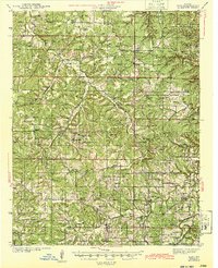
1943 Map of Bado
USGS Topo · Published 1943About this map
Mark Twain National Forest dominates the Ozark landscape of this 1940s survey, illustrating a rural Missouri region defined by steep hollows and upland ridges. The mapping of Roubidoux Creek and the Big Piney River reveals a network of dispersed homesteads and community hubs such as Success, Ellis Prairie, and Huggins. Industrial activity is marked by the presence of a Barium Mine in the northeast, while the Vada Lookout points to the early conservation efforts within the forest boundaries.
Find a feature on this map
90 named features on this map. Tap any name to fly to it.
Don’t see what you’re looking for? This feature index may not catch every label — zoom into the map to look around manually.
Map Details
Editions of this 1943 Bado Map
3 editions found
Other maps of this area

1931 · Manes
USGS Topo · 1:48,000

1937 · Edgar Springs
USGS Topo · 1:48,000

1941 · Big Piney
USGS Topo · 1:62,500

1941 · Manes
USGS Topo · 1:62,500

1941 · Bado
USGS Topo · 1:62,500

1943 · Big Piney
USGS Topo · 1:62,500

1943 · Manes
USGS Topo · 1:62,500

1943 · Drynob
USGS Topo · 1:62,500

1943 · Bado
USGS Topo · 1:62,500

1945 · Edgar Springs
USGS Topo · 1:62,500