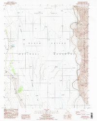
1986 Map of Badwater
USGS Topo · Published 1987About this map
The Lowest Point in United States -282 Feet sits at the heart of this mid-1980s survey, marking the extreme geography of Badwater Basin. The landscape is dominated by the alkaline floor of Death Valley National Monument, where the Amargosa River terminates into vast Salt Flats and areas of mud and alkali. Along the western edge, historical human presence is recorded at Bennetts Well and Eagle Borax Well, alongside the Dayton Harris Grave Mon near the Dayton Harris Gravity Station 2577. To the east, the Black Mountains rise sharply from the valley floor, cut by the descriptively named Coffin Canyon and Copper Can. The map illustrates a stark environment of salt crusts and seasonal water, including the crystalline expanse of the Devils Golf Course.
Find a feature on this map
17 named features on this map. Tap any name to fly to it.
Don’t see what you’re looking for? This feature index may not catch every label — zoom into the map to look around manually.
Map Details
Editions of this 1986 Badwater Map
2 editions found
Other maps of this area

1908 · Furnace Creek
USGS Topo · 1:250,000

1910 · Furnace Creek
USGS Topo · 1:250,000

1948 · Death Valley
USGS Topo · 1:250,000

1951 · Funeral Peak
USGS Topo · 1:62,500

1952 · Furnace Creek
USGS Topo · 1:62,500

1952 · Ryan
USGS Topo · 1:62,500

1952 · Bennetts Well
USGS Topo · 1:62,500

1954 · Death Valley
USGS Topo · 1:250,000

1956 · Death Valley
USGS Topo · 1:250,000

1957 · Death Valley
USGS Topo · 1:250,000