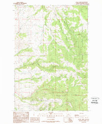
1989 Map of Baggs Creek
USGS Topo · Published 1989About this map
Helena National Forest and Deerlodge National Forest converge in this high-altitude drainage of Powell County, Montana. The map detail centers on a complex hydrologic network defined by the South Fork and Middle Fork Spotted Dog Creeks, which carve through the terrain alongside Fred Burr Creek and Baggs Creek. This 1980s-era revision of earlier surveys provides a clear look at the area's resource-driven geography, where the mountainous landscape is marked by the Hidden Hand Mine and several unidentified Prospects in the southern reaches near Rocker Gulch. The absence of developed townsites or major highways highlights the wilderness character of the forest boundary, emphasizing the importance of small watercourses like Freezeout Creek and Joke Creek for navigating this section of the Rocky Mountains.
Find a feature on this map
18 named features on this map. Tap any name to fly to it.
Don’t see what you’re looking for? This feature index may not catch every label — zoom into the map to look around manually.
Map Details
Editions of this 1989 Baggs Creek Map
This is the sole edition of this map. No revisions or reprints were ever made.
Other maps of this area

1889 · Helena
USGS Topo · 1:250,000

1893 · Helena
USGS Topo · 1:250,000

1899 · Boulder
USGS Topo · 1:125,000

1899 · Helena
USGS Topo · 1:250,000

1903 · Helena
USGS Topo · 1:250,000

1947 · Butte
USGS Topo · 1:250,000

1954 · Basin
USGS Topo · 1:62,500

1958 · Butte
USGS Topo · 1:250,000

1958 · Avon
USGS Topo · 1:62,500

1959 · Deer Lodge
USGS Topo · 1:62,500