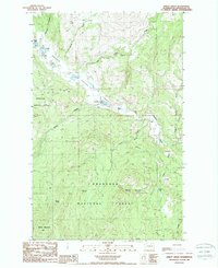
1988 Map of Bailey Creek
USGS Topo · Published 1988About this map
Okanogan National Forest encompasses the majority of this high-elevation landscape in the late 1980s, where the West Fork Sanpoil River carves through the central valley. This area of Washington is defined by a patchwork of land use, including an Indian Allotment and a small Landing Strip situated near Catherine Cecile Lake. Local topography is pronounced by features like Bailey Mountain and the deep cut of Devils Canyon. The map records a series of small, high-country lakes such as Round Lake and Ell Lake, each equipped with a Boat Ramp, suggesting a landscape utilized for both managed timber and seasonal recreation. Pockets of early settlement or family landmarks are visible in labels like Labelle and a small Cem located just north of the river, providing a record of rural life before further modernization.
Find a feature on this map
26 named features on this map. Tap any name to fly to it.
Don’t see what you’re looking for? This feature index may not catch every label — zoom into the map to look around manually.
Map Details
Editions of this 1988 Bailey Creek Map
This is the sole edition of this map. No revisions or reprints were ever made.
Other maps of this area

1902 · Osoyoos
USGS Topo · 1:125,000

1904 · Osoyoos
USGS Topo · 1:125,000

1904 · Republic
USGS Topo · 1:125,000

1951 · Wauconda
USGS Topo · 1:62,500

1952 · Disautel
USGS Topo · 1:62,500

1953 · Bald Knob
USGS Topo · 1:62,500

1954 · Okanogan
USGS Topo · 1:250,000

1957 · Aeneas Valley
USGS Topo · 1:62,500

1958 · Okanogan
USGS Topo · 1:250,000

1958 · Aeneas
USGS Topo · 1:62,500