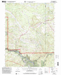
1994 Map of Bailey
USGS Topo · Published 2001About this map
Bailey and the surrounding river canyon of the North Fork South Platte River define this mountain landscape in the mid-1990s. The map illustrates a network of small residential and resort pockets along the river and highways, including Glenisle, Insmont, and Estabrook. Higher elevations are characterized by significant relief, featuring Mount Bailey and Crooked Top Mountain, while the northeast corner shows the development hub of Pine Junction. This area within the Pike National Forest shows the legacy of early mountain settlement through features like the Deer Creek School and a Cem located near the Roland road. Evidence of historical activity is visible in the various Prospects and the Mine Prospect situated near Crossons, indicating the region's long history of small-scale mineral exploration and canyon-floor industry.
Find a feature on this map
44 named features on this map. Tap any name to fly to it.
Don’t see what you’re looking for? This feature index may not catch every label — zoom into the map to look around manually.
Map Details
Editions of this 1994 Bailey Map
This is the sole edition of this map. No revisions or reprints were ever made.
Other maps of this area

1893 · Platte Canyon
USGS Topo · 1:125,000

1899 · West Denver
USGS Topo · 1:125,000

1903 · Georgetown
USGS Topo · 1:62,500

1905 · Georgetown
USGS Topo · 1:62,500

1945 · Pine
USGS Topo · 1:24,000

1945 · Bailey
USGS Topo · 1:24,000

1945 · Shawnee
USGS Topo · 1:24,000

1948 · Pine
USGS Topo · 1:24,000

1948 · Shawnee
USGS Topo · 1:24,000

1949 · Bailey
USGS Topo · 1:24,000