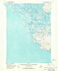
1954 Map of Baird Inlet A-7
USGS Topo · Published 1971About this map
Chefornak sits along the winding banks of the Kinia River in this mid-century survey of the Alaskan coast. The landscape is dominated by the intricate wetlands and tidal flats of the Clarence Rhode National Wildlife Range Area No 2, where the river loops toward its outlet at Kinak Bay. Rising above the surrounding marshes, Tern Mountain provides a rare point of elevation in an area defined by its relationship with the water. The coastline meets the Etolin Strait, revealing a complex network of small ponds and unnamed waterways that characterize this part of the Yukon-Kuskokwim Delta. Researchers will find the small settlement of Chefornak and its nearby Cemetery as the primary human landmarks in this otherwise remote coastal environment.
Find a feature on this map
8 named features on this map. Tap any name to fly to it.
Don’t see what you’re looking for? This feature index may not catch every label — zoom into the map to look around manually.
Map Details
Editions of this 1954 Baird Inlet A-7 Map
This is the sole edition of this map. No revisions or reprints were ever made.
Other maps of this area

1951 · Kuskokwim Bay
USGS Topo · 1:250,000

1951 · Baird Inlet
USGS Topo · 1:250,000

1954 · Baird Inlet
USGS Topo · 1:250,000

1954 · Kuskokwim Bay
USGS Topo · 1:250,000

1954 · Baird Inlet B-6
USGS Topo · 1:63,360
1954 · Kuskokwim Bay D-6
USGS Topo · 1:63,360

1954 · Baird Inlet B-7
USGS Topo · 1:63,360

1954 · Baird Inlet B-8
USGS Topo · 1:63,360
1954 · Kuskokwim Bay D-7
USGS Topo · 1:63,360
1954 · Baird Inlet A-6
USGS Topo · 1:63,360