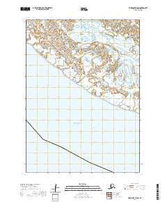
2020 Map of Baird Inlet B-8 SW
USGS Topo · Published 2020About this map
Etolin Strait dominates the southeastern quadrant of this coastal survey, where the waters of the Bering Sea meet the intricate network of wetlands and tidal flats that define the Alaskan coastline in the Bethel Census Area. The landscape is characterized by a high concentration of small ponds and unnamed water bodies typical of the Yukon-Kuskokwim Delta region. The map provides a precise delineation of the shoreline and the transition from open sea to the inland aquatic systems, documented through hydrography data spanning from 2003 to 2019. While no permanent settlements are named on this specific sheet, the Public Land Survey System grid tracks across the terrain, marking boundaries for t3n r90w and surrounding townships, offering a clear view of the geographic structure of this remote coastal area as it existed in 2020.
Find a feature on this map
7 named features on this map. Tap any name to fly to it.
Don’t see what you’re looking for? This feature index may not catch every label — zoom into the map to look around manually.
Map Details
Editions of this 2020 Baird Inlet B-8 SW Map
This is the sole edition of this map. No revisions or reprints were ever made.
Other maps of this area

1951 · Nunivak Island
USGS Topo · 1:250,000

1951 · Baird Inlet
USGS Topo · 1:250,000

1954 · Nunivak Island
USGS Topo · 1:250,000

1954 · Baird Inlet
USGS Topo · 1:250,000

1954 · Nunivak Island B-1
USGS Topo · 1:63,360

1954 · Baird Inlet B-8
USGS Topo · 1:63,360

1958 · Nunivak Island
USGS Topo · 1:250,000

1964 · Nunivak Island
USGS Topo · 1:250,000
2020 · Nunivak Island B-1 NE
USGS Topo · 1:25,000
2020 · Baird Inlet B-8 NW
USGS Topo · 1:25,000