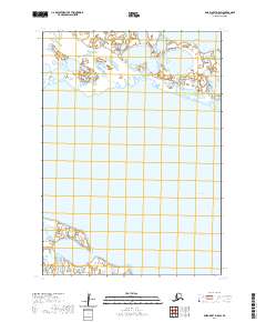
2020 Map of Baird Inlet D-5 SW
USGS Topo · Published 2020About this map
Baird Inlet dominates the southern reaches of this landscape in the Bethel Census Area, where the vast water body meets a complex network of coastal wetlands and tidal flats. The northern portion of the map is defined by Kaghasuk Lake, a significant water feature situated within the transition of the Yukon-Kuskokwim Delta. This 2020 survey, published by the U.S. Geological Survey, meticulously tracks the subtle hydrography of the region, including the intricate township and range lines of t9n r81w and t8n r82w. The terrain is characterized by a high concentration of small ponds and interconnected waterways, illustrating the dynamic hydrology of the Alaskan tundra and its seasonal shifts. Researchers interested in the environmental changes of the delta will find a precise record of the shoreline and internal drainage patterns as they existed in the early 21st century.
Find a feature on this map
6 named features on this map. Tap any name to fly to it.
Don’t see what you’re looking for? This feature index may not catch every label — zoom into the map to look around manually.
Map Details
Editions of this 2020 Baird Inlet D-5 SW Map
This is the sole edition of this map. No revisions or reprints were ever made.
Other maps of this area

1951 · Baird Inlet
USGS Topo · 1:250,000
1953 · Baird Inlet C-5
USGS Topo · 1:63,360

1953 · Baird Inlet D-5
USGS Topo · 1:63,360
1953 · Baird Inlet C-6
USGS Topo · 1:63,360

1954 · Baird Inlet D-6
USGS Topo · 1:63,360

1954 · Baird Inlet
USGS Topo · 1:250,000
2020 · Baird Inlet D-5 SE
USGS Topo · 1:25,000
2020 · Baird Inlet D-5 NW
USGS Topo · 1:25,000
2020 · Baird Inlet C-5 NW
USGS Topo · 1:25,000
2020 · Baird Inlet D-6 NE
USGS Topo · 1:25,000