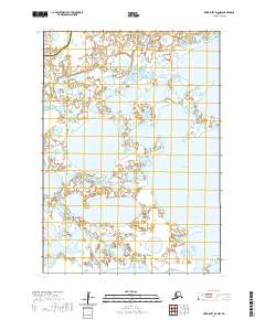
2020 Map of Baird Inlet D-6 NW
USGS Topo · Published 2020About this map
The Ciissinraq River meanders across this subarctic landscape in the Bethel Census Area, defining a complex network of wetlands and tundra ponds typical of the Yukon-Kuskokwim Delta. The boundary between the Bethel Census Area and the Kusilvak Census Area cuts across the northwest corner of this sheet, marking a significant administrative division in this roadless region. Significant water bodies such as Lou Lake and Kagalurpak Lake dominate the central terrain, while Mouse Point provides a named landmark along the eastern interior marshes. This survey captures the intricate hydrography of the Alaskan delta just before the 2020s, illustrating the shifting boundaries of water and land in an area defined by its seasonal cycles.
Find a feature on this map
5 named features on this map. Tap any name to fly to it.
Don’t see what you’re looking for? This feature index may not catch every label — zoom into the map to look around manually.
Map Details
Editions of this 2020 Baird Inlet D-6 NW Map
This is the sole edition of this map. No revisions or reprints were ever made.
Other maps of this area

1951 · Marshall
USGS Topo · 1:250,000

1951 · Baird Inlet
USGS Topo · 1:250,000

1954 · Baird Inlet D-6
USGS Topo · 1:63,360

1954 · Marshall A-6
USGS Topo · 1:63,360
1954 · Marshall A-7
USGS Topo · 1:63,360

1954 · Baird Inlet D-7
USGS Topo · 1:63,360

1954 · Marshall
USGS Topo · 1:250,000

1954 · Baird Inlet
USGS Topo · 1:250,000
2020 · Marshall A-6 SE
USGS Topo · 1:25,000
2020 · Marshall A-6 SW
USGS Topo · 1:25,000