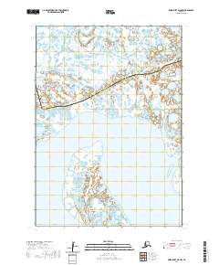
2020 Map of Baird Inlet D-8 NW
USGS Topo · Published 2020About this map
The Kumlunak Peninsula dominates the southern portion of this landscape, extending into a complex network of coastal waters and wetlands along the western Alaska coast. This 2020 map documents the shifting boundary between the Kusilvak Census Area and Bethel Census Area, which cuts diagonally across the northern marshlands. The terrain is defined by a labyrinth of small lakes and ponds characteristic of the delta region, where land and water are constantly in flux. To the north, the Kealavik River meanders through the low-lying tundra, illustrating the intricate drainage patterns of this subarctic environment. The lack of permanent structures or roads reflects the seasonal and traditional uses of the land, providing a contemporary view of this remote geography as recorded by the U.S. Department of the Interior and the U.S. Geological Survey.
Find a feature on this map
9 named features on this map. Tap any name to fly to it.
Don’t see what you’re looking for? This feature index may not catch every label — zoom into the map to look around manually.
Map Details
Editions of this 2020 Baird Inlet D-8 NW Map
This is the sole edition of this map. No revisions or reprints were ever made.
Other maps of this area

1951 · Marshall
USGS Topo · 1:250,000

1951 · Hooper Bay
USGS Topo · 1:250,000

1951 · Nunivak Island
USGS Topo · 1:250,000

1951 · Baird Inlet
USGS Topo · 1:250,000

1953 · Hooper Bay
USGS Topo · 1:250,000

1954 · Nunivak Island
USGS Topo · 1:250,000
1954 · Marshall A-8
USGS Topo · 1:63,360

1954 · Marshall
USGS Topo · 1:250,000

1954 · Baird Inlet
USGS Topo · 1:250,000

1954 · Baird Inlet D-8
USGS Topo · 1:63,360