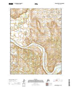
2019 Map of Baird Mountains A-1 NE
USGS Topo · Published 2019About this map
The Kobuk Valley National Park landscape is defined by the sweeping arc of the Kobuk River as it winds through this remote Arctic territory. This 2019 survey captures the river's dynamic path, including the significant oxbows and shifts in the main channel that characterize the local hydrology. Joining from the north, the Kalliguricheark River feeds into the larger waterway, highlighting a drainage system largely undisturbed by permanent infrastructure or settlements. The map provides a detailed view of the terrain within several township boundaries, including t21n r2w and t20n r2w, where the natural topography remains the primary focus. Without roads or modern developments, this sheet serves as a record of the Northwest Arctic's wilderness, preserving the exact state of these riverbanks and parklands in the early twenty-first century.
Find a feature on this map
7 named features on this map. Tap any name to fly to it.
Don’t see what you’re looking for? This feature index may not catch every label — zoom into the map to look around manually.
Map Details
Editions of this 2019 Baird Mountains A-1 NE Map
This is the sole edition of this map. No revisions or reprints were ever made.
Other maps of this area

1951 · Baird Mountains
USGS Topo · 1:250,000

1951 · Ambler River
USGS Topo · 1:250,000

1955 · Baird Mountains A-1
USGS Topo · 1:63,360

1955 · Ambler River A-6
USGS Topo · 1:63,360

1956 · Ambler River
USGS Topo · 1:250,000

1956 · Baird Mountains
USGS Topo · 1:250,000

1964 · Ambler River
USGS Topo · 1:250,000

1965 · Baird Mountains
USGS Topo · 1:250,000
1990 · Ambler River B-6
USGS Topo · 1:63,360
1990 · Baird Mountains B-1
USGS Topo · 1:63,360